
Daniel Swafford, Executive Director of the Laurel District Association submitted the below project narrative to OakDOT as a Capital Improvement Program (CIP) project request. Daniel will be presenting this at the February 4th, 2021 BPAC Infrastructure Committee meeting for discussion.
Notes from the presentation and discussion are below.
MacArthur Blvd Lane Reduction Capital Improvement Project – 35th Ave. to High St. – The Laurel
S.L.O.W. Laurel [Safe Livable Open Welcoming]
An Appeal to Reduce Traffic Lanes (4 > 2) on MacArthur for a Livable Community
History and Progress to Date
The Laurel District, located in East Oakland along MacArthur Blvd. between 35th Avenue on the West and High Street on the East, is a bustling mixed-use neighborhood straddling MacArthur Blvd. The District is home to a rich diversity of local, small businesses, restaurants, apartments and schools. The community is recognized as the 8th most diverse zip code in the nation, where a majority of residents are Black and Asian, together making up more than 66 percent of the total population. The neighborhood deals with a unique set of circumstances that make traffic safety challenging for small business owners, commuters, pedestrians, and cyclists alike.
Running through the heart of the neighborhood is one of Oakland’s great streets, MacArthur Blvd., which was originally built as U.S. Route 50, a major cross-country highway, in the 1940’s. Later, MacArthur was more commonly used as a pass-through for large volumes of traffic, and now acts as a ramp for commuters heading to or coming off of I–580.
To capture data on traffic trends in The Laurel District, The Laurel District Association, a Business Improvement District (BID) formed in 2005, partnered with Mills College MPP Graduate Program to conduct an initial traffic and safety study along with a community survey to get a better understanding of how local residents feel about the current conditions. The 2018 study outlined three key findings:
1) Four Traffic Lanes Facilitate High Rates of Speeding
On a daily basis, vehicles are observed exceeding 65 mph in a 25 mph zone, weaving through cars, crossing the center lane, and running red lights. Many of the incidents happen during business hours when pedestrian traffic is highest and have caused tragedies such as:
- A driver being killed after colliding with a street tree at an excessive speed in 2018.
- Damage to storefronts forcing temporary or prolonged closure of businesses on at least four occasions in 2020.
- Cyclist killed by AC Transit bus in 2010 due to insufficient space between parking and traffic lane.
2) Traffic Lane Width is Too Narrow and Not to Code
The four traffic lanes are especially narrow, originating from when MacArthur Blvd. was a highway prior to the construction of I-580. This is a significant safety impediment for vehicles, busses, and cyclists for reasons including:
- Vehicles are forced to crowd the parking lane causing unsafe conditions.
- AC Transit busses are unable to fit in a single traffic lane.
- Cyclists are too crowded and obliged to ride in the “door zone” of parked vehicles.
3) Traffic Congestion is Causing Increasingly Dangerous Conditions
Less than 2,000 residents live in the area, yet over 16,300 drivers and 11,350 AC Transit riders pass through the Laurel District daily. These factors combined with certain conditions are extremely detrimental.
- Low visibility intersections make pedestrian use difficult and hazardous.
- Due to inadequate traffic mitigation, accidents are increasing.
Proposed Solution to the Laurel District’s Challenges: A Traffic Calming Plan
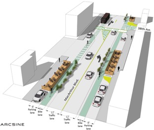
A capital improvement project—S.L.O.W. Laurel [Safe Livable Open Welcoming Laurel]—is a lane reduction, “road diet” proposal, which reduces four traffic lanes to two, builds out open-air dining, and incorporates bike lanes on the section of MacArthur Blvd. located in The Laurel District of Oakland, California. The section of road is a mixed-use area located between 35th Ave and High Street. Below is a rendered drawing with descriptions of key features.
- Controls traffic lanes with reduced lanes.
- Expands public use area for adjacent businesses.
- Creates safe travel for cyclists’ bike lanes.
- Creates space for AC Transit to fully pull to curb.
- Capitalizes on store fronts as shopping moments.
General Project Goals
As outlined above, S.L.O.W. Laurel will reduce 4 traffic lanes to 2 on a section of MacArthur Blvd., connecting to vital City of Oakland Transportation (OakDOT) projects to procure a safe, accessible, and inviting commercial corridor through The Laurel District. The goal is to address the outlined critical traffic hazards in order to provide a safe environment, with access for all mobilities including motorists, pedestrians, cyclists, and public transit. The top traffic calming solutions would also include improving crosswalks with flashing lights or better timed signals, building parklets, adding bike lanes, and widening traffic lanes. General project goals include:
- Closing Gaps in Oakland’s Transportation Plans by aligning with established upgrades and enhancing utilization of established OakDOT investments along MacArthur Blvd. It will connect to the transportation initiative LAAMPS (Laurel Access to Mills, Maxwell Park and Seminary) at High Street and with Oakland’s Master Bicycle Plan (Let’s Bike Oakland) West of 35th Ave.
- Promoting Collaboration with Stakeholders by working toward a common goal of creating a safe, pleasant experience for visitors and residents along MacArthur Blvd. This encourages patronizing multiple businesses in one visit, benefiting merchants, residents, and the City of Oakland at large.
- Improving Geographic Equity reducing traffic lanes facilitates enhanced access for all mobilities, improving geographic equity in Oakland. Vehicle, bike lane and pedestrian safety upgrades through The Laurel District would improve access to essential goods and services including mass transit hubs for residents in some of our highest equity need areas South of MacArthur Blvd. and East of High Street. Small and minority-owned businesses in The Laurel Commercial District would directly benefit from a more walkable corridor, reducing barriers to access, and making the shopping experience safe and enjoyable.
- Slowing Traffic for Safe and Livable Streets: Reducing lanes and slowing down traffic would enable parklets, outdoor seating, and greenscaping to be developed.
- Improving Quality of Life for Residents: There would be an increase in foot traffic and longer stays in the neighborhood to support the arts & culture. Noise & air pollution would decline as well.

Evaluation Criteria
HEALTH & SAFETY – A Critical Factor – Intense traffic volume and aggressive driver behavior decreases both the perception and reality of safety in the Laurel District. Unmitigated driver behavior is causing increasingly dangerous conditions. The area houses less than 2,000 residents, yet over 16,300 drivers and 11,350 AC Transit riders pass through daily.
- Low visibility intersections make pedestrian use difficult and hazardous: During a thorough traffic analysis in 2019, up to 257 pedestrians were recorded crossing in one intersection in a three hour period with near misses and collisions taking place regularly. There are several other similar crosswalks in The Laurel District. (Mills College Graduate Student Project).
- Accidents are increasing: There were 11 major traffic accidents reported and in 2015 compared to 15 accidents in 2017 along the McArthur Blvd. corridor from High Street to 35th Avenue. (City of Oakland).
EQUITY – Safe access to bike, pedestrian, and transit routes to Downtown and West Oakland (Kaiser, Summit and other hospitals; the transbay connection and regional transit hubs), will connect essential goods and services in The Laurel District to the diverse population of East Oakland neighborhoods.
- With a population that is roughly 27% Black, 20% Asian, and 16% Latinx, the Laurel District is one of the most diverse zip codes in the nation. This diversity is reflected in the district’s business ownership as well.
- Laurel Elementary is two blocks from the heart of the District. Allendale Elementary, Allendale Rec. Center, Brookdale Rec. Center, The Boys and Girls Club, and over a dozen pre-schools and churches are within ¼ mile. These children, youth, and families will all benefit from safer routes along MacArthur Blvd.
EXISTING CONDITIONS – The project will remediate old industrial infrastructure outlined below and close the gap in OakDOT’s Master Bike Plan.
Traffic Lane Width is Too Narrow and Not to Code: The four traffic lanes are especially narrow, originating from MacArthur Blvd. being a highway prior to the construction of I-580, creating a significant safety impediment for vehicles, busses and cyclists for reasons including:
- Vehicles are forced to crowd the parking lane causing unsafe conditions for people entering and exiting parked cars which leads to numerous incidents and near misses.
- AC Transit busses are unable to fit in a single traffic lane and straddle both lanes of directional traffic. Vehicles are constantly crossing the center lane to pass.
- Cyclists are too crowded and obliged to ride in the “door zone” of parked vehicles. This crowding is what led to the death of a cyclist who was hit by an AC Transit bus after swerving to avoid a car door opening at Loma Vista and MacArthur Blvd. in 2010.
Four Traffic Lanes Facilitate High Rates of Speeding: Vehicles are observed daily exceeding 65 mph in a 25 mph zone, weaving through cars, crossing the center lane, and running red lights. Many of the incidents happen during business hours when pedestrian traffic is highest and have caused incidents such as:
- Damage to storefronts forcing temporary or prolonged closure of the businesses on at least four occasions in 2020.
- A driver being killed after colliding with a street tree at an excessive speed in 2018. In collisions at 30 mph, one in five pedestrians will not survive, with odds being significantly worse for older pedestrians (AAA Safety Foundation).

Closing Gaps in City of Oakland Master Bike Plan: Our plan—S.L.O.W. Laurel [Safe Livable Open Welcoming Laurel]—will connect a vital City of Oakland transportation project LAAMPS (Laurel Access to Mills, Maxwell Park and Seminary) at High Street and the The City of Oakland’s Master Bicycle Plan (Let’s Bike Oakland) with dedicated bike lanes west of 35th and east of High St, creating linkage to Downtown Oakland, West Oakland, and East Oakland, and procuring a safe and inviting commercial corridor in The Laurel District by reducing 4 traffic lanes to 2 on a section of MacArthur Blvd.
ECONOMY – Our Locally Owned Ethnic Businesses Need Us Now More Than Ever
- The Laurel District has a diverse commercial center, connecting East Oakland neighborhoods to culturally diverse locally owned and independent small businesses. There is a high level of interest among District merchants in the project with vocal support from large anchors to small independent businesses as traffic improvements to the street would improve safety and thus generate commerce.
PROJECT READINESS – A Defined Need and Willing Community
- Many community members do not feel safe. In a survey conducted with 132 residents and business owners regarding how they felt about their safety while walking, 31.8 percent reported feeling very unsafe to unsafe walking, while 59 percent reported experiencing an instance in which they felt threatened due to traffic conditions (Mills College Graduate Student Project; Transforming Traffic Problems in The Laurel District – Evaluations and Applications; Crystal Rocha – May 2018).
- Oakland voters are behind improvement and approved two ballot measures in support of public safety and investment in streets through Measure KK and Measure BB, which passed with more than 70 percent support.
ENVIRONMENT – Making Commercial Corridors a Healthy Environment
- There would be an increase in foot traffic and longer stays in the neighborhood to support the arts & culture. Noise & CO2 pollution would decline as well. A more walkable community increases key health and wellness factors for residents.
REQUIRED WORK – A Remedy for Unsafe Conditions
- The top solutions include flashing lights at crosswalks, parklets, decreased number of traffic lanes, added bike lanes, and widened sidewalks.
- Required work could be phased in with re-striping and temporary infrastructure (large planters, bollards) installed, and as funds are secured, more significant infrastructure work could be added.
IMPROVEMENT – Supporting and Growing All Modes of Transport
- Currently The Laurel District has a four lane road configuration along MacArthur Blvd. whereas traffic flows immediately to the East and West have been upgraded with reduced traffic lanes, wider lanes, and the inclusion of dedicated bike lanes. Closing the bikeway gap and upgrading the roadway configuration would promote safety and improve access to the LAMMPS (Laurel Access to Mills, Maxwell Park and Seminary) streetscape which has incorporated a wide range of improvements such as curb ramps, crosswalks, pedestrian lights, landscaping, bicycle lanes, multi-use paths, new traffic signals reconfigured intersections, pavement marking and striping. The City of Oakland’s Master Bicycle Plan (Let’s Bike Oakland) would also be accessible.
COLLABORATION – A Grassroots Community Initiative and City Partnership
- Community’s input was considered via community surveys and a road diet evaluation was conducted with Mills College in 2018. LDA also developed agendas and posted conversations at six monthly board meetings beginning in 2019 along with informal meet ups with merchants. MacArthur Blvd. is relatively narrow so collaboration with both AC Transit and cyclists to allow adequate space to accommodate these modes would be required to ensure safe left turns and driveway access.
- Stakeholders involved in the collaboration include: Laurel Village Association, Redwood Heights Neighborhood Association, Maxwell Park Neighborhood Association, Mills College, Bike East Bay, Walk Oakland Bike Oakland (WOBO), OakDOT, Caltrans District 4, Councilmember Thao, Alameda County Supervisor Nate Miley, and Arcsine architecture.
SHOVEL READY – If Not Now, When?
- LDA has been working with OakDOT on project readiness and has designated initial funds by working with Mills College to assess the benefit of a lane reduction. Design concepts are currently being procured by Arcsine for the concept and LDA.
Presentation
- Focusing on the Laurel on MacArthur corridor, from 35th Ave to High Street
- Connects to recent bike/walk improvements east of High Street to Mills College
- Pushing for a long term improvements to offset steadily increasing traffic safety issues
- Lots of commercial activity—retail, dining, schools, street festivals
- Applied for inclusion in Oakland’s recent CIP process to receive potential funding
- Partnered with Mills College in 2018 to complete traffic safety study and survey. Will do another merchant outreach survey this semester
- Street designed back when MacArthur was Highway 50, before 580 was constructed—not based on current traffic needs
- Some very minor upgrades so far—Crosswalk restriping, one signal retimed
- Restaurant owners reluctant to install on-street dining parklets due to current street safety issues
Discussion
- Bike traffic is not protected in the concept illustration, mixed traffic, would parking-protection be feasible?
- Have had some conversations with staff. The street width is a little less than 55’ with lots of competing needs—possibility for “multi-use lane” for biking and other activities—not enough space for dream scenario. Want staff planners and engineers to figure out what’s possible.
- Has AC Transit been contacted about bus service on the street, to avoid service slowdowns? Line 57 struggles to get across High Street during peak
- Designing for articulated buses is important—Will solicit feedback from AC Transit. Some stop consolidation or relocation could help.
- Laurel District Association representative: Current sharrow (shared lane) markings aren’t enough. Driver behavior won’t change without structural changes like lane reduction. Appreciates slow streets during covid-19, wants to make them permanent.
- After some District 6 and 7 road diets, drivers go into the bike lane to pass other cars. Physical separation is needed to help to avoid this.
- AC Transit Major Corridors Study is included in this segment. There are some specific recommendations which could be incorporated into this project.
- CIP project
- Craig Raphael with the City will be reviewing the CIP process with the full BPAC.

I really hope to see this plan implemented fully, and soon. This corridor poses real safety issues that are not too complicated to address. Being a pedestrian or cyclist in the Laurel is a nightmare. Please prioritize and fast track these plans so that we can enjoy the area and support the businesses there!
LikeLike
Great idea!
Traffic calming to protect pedestrians, cyclists, and drivers is sorely needed and would help with local businesses.
LikeLike
I honestly believe that his will greatly enhance the quality of life for all of us that live in this district. The current road use is unsafe, unpleasant, and outdated. I would love to see this plan come to fruition and am grateful that we are looking in this direction!
LikeLike
Looks good to me but I wish parking was easier in the laurel. Dimond has LOtS of parking! And why aren’t there parking app numbers for the parking app?
LikeLike
Susan, thanks for your comment. I am familiar with both areas. Would you provide specifics on where on Macarthur you have difficulty finding parking. I know the area by Laurel Cyclery is tight but it doesn’t extend to all. Also where in Dimond is parking plentiful? If it’s by Farmer Joe’s perhaps it’s because the businesses are sizable and have their own parking.
LikeLike
There are three large free public parking lots in Dimond. . One behind peets on fritvale as well as on the other side of the street behind tmobile and another behind Wells Fargo.
There are zero public lots in Laurel.
LikeLike
Is there any way you can fix the three broken images on this post? AFAICT it is the best public documentation of what S.L.O.W. Laurel means. And, according to a CIP email I just got, S.L.O.W. Laurel is still alive and well as part of the “MacArthur: Lakeshore to East Oakland” planning project. I’m not really even sure what the images are, but makes the post look old / unmaintained. Thanks!
LikeLike
Sorry, I don’t know why the images broke. Here is the original file:
https://drive.google.com/file/d/1HaKHXjD8mbN-EjcBWQ0Clv_lmR5xDQOT/view
LikeLike
Is there any recent progress regarding this proposal? I see that LAMMPS Phase 2 planning is moving forward – which is great , and also seems like a good time to revisit this vital stretch.
LikeLike
Hi Adam, you can check the CIP page: https://www.oaklandca.gov/topics/capital-improvement-program and contact OakDOT staff directly for an update. Thank you
LikeLike