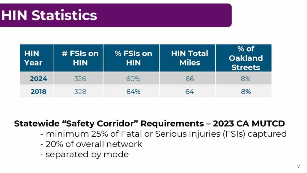
At the May 23, 2024 BPAC meeting, Charlie Ream and Ofurhe Igbinedion, PhD from OakDOT’s Planning and Project Development Team will provide an update on Oakland’s recently updated High Injury Network (HIN). The 2018 HIN used data from 2012-2016 and the 2024 HIN uses 2017-2021 data with some adjustments for recent fatalities.
An excerpt is below, followed by the full presentation.
Introduction — High-Injury Network
- Foundation for resource allocation decisions at OakDOT related to traffic safety:
- Capital Improvement Plan
- Complex Paving
- Project Development/Grant Applications
- Automated Speed Enforcement Pilot (AB 645)
- Key to Safe Oakland Streets (SOS) goals of reducing and eliminating fatal and severe crashes
- Identify highest density of most severe crashes; Fatal or Severely Injured (FSI)
- Communicate priorities with community
Methodology
- ESRI GIS Consultant: “Sliding Window” analysis
- .5 mile segments (.1 added together)
- Crash Weighting – 4 crash types: 1 (most severe) – 4 (least)
- Motor Vehicle (1,2 = 3pts; 3,4 = 0pts) – many more crashes overall
- Pedestrian and Bicycle (1,2 = 3pts; 3=1pt, 4 = 0pts) – fewer crashes overall
- Property Damage Only not included
- Data Inclusion
- 2017-2021 Transportation Injury Mapping System (TIMS)
- Mapped Statewide Integrated Traffic Records System (SWITRS)
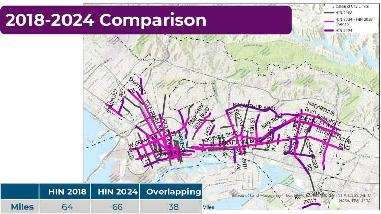
- Previous 2018 map used 2012-2016
- 2017-2021 Transportation Injury Mapping System (TIMS)
- Post-processing/Quality Control
- Kept segments from 2018 HIN if there was a recent fatality, general cleanup
Presentation