At the February 4th, 2021 BPAC Infrastructure Committee meeting, Jennifer Stanley, OakDOT staff from the Bicycle & Pedestrian Section, presented the revised draft of the Neighborhood Bike Routes Implementation Guide. The previous draft is here.
Notes from the presentation and discussion are below.
Neighborhood Bike Route Implementation Guide
REVISED DRAFT, last updated January 26, 2021
Map and Figures (numbering to be updated)
This Guide provides direction on implementing the City of Oakland’s bike plan: Let’s Bike Oakland! (2019) recommendations for “neighborhood bike routes” (NBRs) also known as “bicycle boulevards.” The bike plan proposes over 75 centerline miles of NBRs defined on page 22 as:
- Calm local streets where bicyclists have priority but share roadway space with automobiles.
- Include shared roadway bicycle markings on pavement and additional traffic calming measures like speed humps or traffic diverters to keep streets comfortable for bicyclists
- Comfortable for bicyclists with wider range of comfort levels
This Guide does not apply to proposed NBRs that are infeasible (e.g. on high-volume bus routes or on arterial streets). See [name of document] for the feasibility of individual NBRs and the criteria by which feasibility was determined.
The bike plan outlines four actions for streets to be designated as NBRs: Improving Major Street Crossings; Reducing or Preventing Speeding; Preventing High Car Volumes; and Increasing Pavement Quality. This Guide describes implementation in five subject areas: Scoping & Monitoring, Route Establishment, Traffic Calming, Traffic Control, and Public Notification & Comment.
1. Scoping & Monitoring
To evaluate the level of traffic calming required, average daily traffic counts, speeds, and five-year collision data should be consulted. [Note: If 311 data is found to be accessible and helpful, this should be included as well.] If access restrictions or stop sign modifications are proposed, other data will be required (see Sections 3 and 4).
OakDOT sets target traffic speeds and volumes for NBRs based on NACTO’s Contextual Guidance for Selecting All Ages and Abilities Bikeways as follows:
- Speeds less than or equal to 20 mph (95th percentile), less than or equal to 2,000 average vehicles per day, and less than 50 vehicles per hour per direction at peak hour; or
- Speeds less than or equal to 25 mph (95th percentile), less than or equal to 1,500 average vehicles per day, and less than 50 vehicles per hour per direction at peak hour.
Projects implementing NBRs on streets with traffic speeds and volumes above these thresholds should strive to reduce speeds and volumes to below these targets. Existing bikeways that exceed these targets will be classified as bike routes, not as NBRs.
Some proposed NBRs may need ongoing monitoring if the existing traffic calming is insufficient to achieve the targets, or if traffic patterns change. If the route is not meeting those targets, additional traffic calming should be considered. This new monitoring system can be incorporated into Oakland’s annual counts program.
2. Route Establishment
An NBR includes pavement markings, bike route signs, traffic calming (typically a minimum of one speed hump/table/cushion per block as feasible), and consideration of pavement quality.
Mid-Block Bicycle Pavement Markings
- Install sharrows per current City standards (Figure 1). (Also see Issues for Further Discussion, below.)
Intersection Bicycle Pavement Markings: No markings are needed at unsignalized rectilinear local/local intersections, where both streets are 40′ wide or less. At other intersections apply the following:
- Use chevrons (Figure 2, and see OakDOT Design Detail RM-10) at:
- Signalized and/or skewed intersections with four or fewer approaches;
- Transitions to/from bike lanes (see markings at 38th Ave and Brookdale Ave); and
- Where one or more streets are wider than 40′.
- Use green-backed sharrows (Figure 3) at:
- Offset intersections;
- Intersections where a bikeway turns;
- Complex multi-legged intersections; and
- Across divided roadways.
Other Pavement Markings: Include speed hump markings, stop stencils (as needed), and centerlines (50 LF) approaching controlled intersections (Figure 4). Avoid the use of edge line stripes and continuous center lines. (Per CA MUTCD Section 3B.01, centerlines are not required on local streets. On urban collectors and arterials, centerlines are required on roads that are at least 20’ wide and have ADTs of 6,000 vehicles per day or greater.)
Bicyclist Guide Signs: Install bicycle guide signs per current City standards (Figure 5). In areas with few supported destinations (per City standards) and where an NBR does not connect to other signed bikeways, guide signs and decision signs may be sufficient. Where the new NBR does not connect to another signed bikeway, signs can be deferred. Also see Issues for Future Discussion, below.
Pavement Considerations: Projects implementing new NBRs should consider the pavement quality on the proposed route in determining the feasibility of the project. If resurfacing would be beneficial but is cost-prohibitive, consider spot pavement repairs or paving only the travel lanes and not the parking lanes. Where possible, work should be coordinated with the City Council-adopted paving prioritization plan.
If the paving plan (or another project) will pave only part of a proposed NBR, the new route should only be implemented in the following situations:
- where the new segment connects to another existing bikeway (example: 45th St, Linden St to Market St);
- where the pavement quality of adjacent segments allows the installation of a longer bikeway; or
- if additional resources for paving have been secured for the adjacent segments.
If one of these three criteria is not met, the new NBR should not yet be designated. However, speed humps and/or other traffic calming should be considered.
3. Traffic Calming
The extent and types of traffic calming treatments should respond to measured traffic volumes and speeds. A minimum of one speed hump per block, for example, may be insufficient for achieving targeted speeds and volumes.
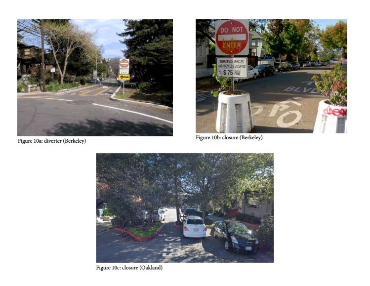
Volume and Speed Management: Discourage through traffic and reduce motor vehicle volumes and speeds through the implementation of traffic calming measures, such as vertical deflection (speed humps/cushions/tables), traffic circles (Figure 6), islands (Figure 7), and diverters (Figures 8a-c). At minimum, an NBR should include one speed hump per block as feasible. Speed humps may not be feasible on all blocks due to block length, street grade, or conflicts with utilities or driveways. Additional speed humps and/or other calming measures should be applied when traffic volumes and/or speeds exceed OakDOT’s guidelines.
Daylighting: Parking may be removed up to 20 feet from the curb return on intersection approaches (standard best practice for all streets).
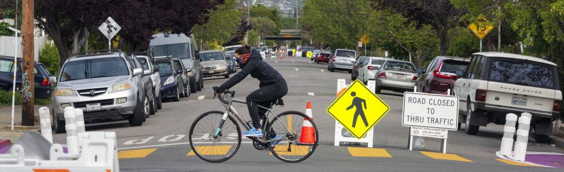
Traffic Restrictions: Current City policy governing street closures is in City Council Resolution 71056 C.M.S. (1994) “RESOLUTION ADOPTING RULES AND REGULATIONS GOVERNING THE PROHIBITION OF ENTRY TO, OR EXIT FROM, OR BOTH FROM CITY STREETS.” To close a street, all of the following conditions must be met:
- the street’s functional classification designates it as a local street;
- where unwarranted through traffic is using the street;
- 67% or more of residents support the change; and
- a determination that the health and safety of the residents of the street and of neighboring streets will not be adversely affected.
Access restrictions (Figures 7 and 8a-c) should be considered where the volume of cut-through traffic is incompatible with a street’s designation as an NBR. Access restrictions should be designed to reduce or eliminate through traffic while allowing local access (e.g., right-in/right-out only at collectors and arterials). Proposals for traffic restrictions require basic study and outreach (per Resolution 71056) and may need an area-wide traffic study and community process to determine where the traffic would be diverted to, to help communicate the diversion to affected residents, and, potentially, to determine if additional traffic calming is needed to address impacts created by that diversion.
Resolution 71056 does not allow partial or full closures to streets classified as collectors or arterials. Such streets could be reclassified as local streets to allow for access restrictions. This reclassification process is managed by Caltrans, as designated by the Federal Highway Administration to oversee the functional classification of California’s roadways. The request process requires a City Council resolution, concurrence by the Metropolitan Transportation Commission, and approval by Caltrans.
4. Traffic Control
Through and cross-traffic on NBRs should be controlled to give bicyclists priority and create safe crossings.
Stop Control at Local Streets: Minimize the number of intersections along NBRs where cross traffic does not stop.
- Intersections of NBRs and local streets should be either (1) stop-controlled on the local approaches only (preferred); or (2) all-way stop-controlled.
- Intersections of two NBRs should be all-way stop-controlled.
- Where stops remain on the NBR, install the supplemental “all way” stop sign placard or “cross traffic does not stop” placard, as applicable (Figures 9 and 10).
- When stops are eliminated on an NBR, monitor post-project traffic volumes and speeds to determine if changes in stop control should be accompanied by traffic calming (if not already included).
Prior to the removal of stop signs:
- Review traffic volumes (vehicle, bicyclist, pedestrian) to ensure the volumes are lower than the thresholds that typically warrant stop signs.
- Conduct a visibility study including sight triangle analysis and approach speed data collection. If visibility is limited, can obstructions be removed or approach speeds reduced? If not, do not remove stop signs. Existing speed data must show speeds that do not create sight distance triangle limitations prior to stop sign removal. (Speed data should not be inferred based on future installations of traffic calming features.)
- Review crash history to ensure there are no crash trends that would be exacerbated by stop sign removal.
Uncontrolled Crossings of Collectors and Arterials: Work to eliminate such crossings. Where they cannot be eliminated, install treatments that support bicyclists at uncontrolled crossings of collectors and arterials. Possible treatments, from low to high intensity and cost, include:
- Bicycle warning signs (Figure 11);
- “BIKE XING AHEAD” pavement legends;
- High-visibility crosswalks (Figure 12);
- Bikeway markings through the intersection;
- Stop signs;
- Median islands (Figure 13);
- Rectangular rapid flashing beacons with bicyclist-accessible
push buttonactuation (Figure 14); - Curb extensions (Figure 15);
- Pedestrian hybrid beacons with passive bicyclist detection (Figure 16); and
- Traffic signals.
Offset Intersections at Collectors and Arterials: NBRs should avoid shared-lane situations on the major street wherever possible. Offset intersection treatments may include:
- Bike lanes (Figure 17);
- Bicycle turn pockets (Figure 18);
- 2-stage turn queue boxes (Figure 19);
- Two-way cycle tracks (Figure 20);
- Pedestrian hybrid beacons with passive bicyclist detection; and
- Traffic signals.
Treatments are context-sensitive and respond to available width, traffic volumes, and the presence of a center turn lane, bike lanes, and/or a traffic signal.
5. Public Notification and Comment
Residents on and near proposed NBRs should be notified early in the project development process when public comments can be addressed. Typically, the City will send a project mailer to addresses within 400’ of the proposed bikeway describing the project and providing an opportunity to weigh in and, optionally, to provide supporting comments. For NBR projects, an additional notification should be sent to addresses immediately adjacent to the locations of proposed traffic calming.
Whether from mailers, surveys, meetings, or other contacts, the City should strive to address legitimate concerns as feasible, such as: locations of speed humps/cushions/tables, traffic circles, or diverters; requests for additional or fewer traffic calming measures. The following concerns are not sufficient for changing a project: bikeways cause crime; bikeways affect property values; the NBR will slow traffic too much.
Issues for Future Discussion
Type of pavement marking. These guidelines assume that low stress bike routes are going to be referred to as Neighborhood Bike Routes in maps and communications materials, and thus recommend the use of sharrows per current City standards (Figure 1). However, some favor City of Berkeley style BIKE BLVD pavement markings (Figure 21) which are larger and convey an understandable “brand.” However, BIKE BLVD markings would not be consistent with the NBR naming. Further, concerns have been raised that local residents may perceive such markings as a harbinger of unwanted gentrification. Some favor an enlarged sharrow marking. Concerns include the ability of contractors to procure and use custom pavement legends.
Additional placemaking signs. To address the following recommendation from the Bike Plan: “OakDOT will engage communities in a collaborative design process to develop placemaking signage for Neighborhood Bike Routes. The signs will complement bicycle wayfinding signage by depicting neighborhood identities.” (p.121).
Modified Street Name Sign. In addition to placemaking signs, and to complement guide signs, a modified street name sign, similar in purpose to those used to mark bike boulevards in Emeryville and Berkeley, could be considered (Figure 22). The advantage of a modified street name sign is that NBRs would be easier to identify—particularly at intersections. A preliminary estimate indicates that 50 street name signs would be required per centerline mile of NBR. To meet this standard along the 14 centerline miles of existing NBRs, it is estimated that 700 street name signs would need to be replaced or modified. [This estimate is based on Cavour St which is 0.2 miles long, with five intersections, and two street name signs per intersection.]
The ”Idaho rule.” When approaching STOP controlled intersections on local streets, most bicyclists yield and do not come to a complete stop. This behavior is typically safe. In recognition of this, the state of Idaho passed a law in 1982 allowing bicyclists to treat STOP signs as yield signs. Similar rules have since been adopted in Delaware, Colorado, Oregon, and Washington. Various attempts have been made to pass this law in California too, but to date, all have failed. If the Idaho rule were adopted in California, the need to remove STOP signs on NBRs would decrease. OakDOT should investigate City support for passage of this statewide legislation which is on the legislative agenda of CalBike for 2021. In addition to simplifying NBR implementation, the legislation would remove some interactions between bicyclists and the police.
Emergency Response Classification Map: Work with OFD, OPD, and other stakeholders to develop a map of emergency vehicle stations and routes and seek review and vetting when proposing traffic calming on major emergency vehicle routes.
Presentation
- The Guide has design element recommendations, but does not state how feasible specific segments might be.
- Divided into five sections dealing with different elements, as well as additional items for future review.
- The screening map overlays existing and proposed neighborhood bikeways with other elements.
- Existing pavement condition is another element which could impact implementation.
- Document polishing/formatting yet to complete, will bring it back to the infrastructure committee to check in.
Discussion
- Lots of what the committee has been talking to staff about has been incorporated into the guide.
- There has been a lot of paving work already completed over the past year, and queued up for 2021, on recommended neighborhood bike route segments which didn’t have these standards applied. City needs to prioritize going back to these segments for updates.
- Any policy updates or other support needed from city council in order to increase implementation?
- Not necessarily, already hearing support for implementation. 1994 city street closure process (following state code), might be ways to think about this differently in order to facilitate guidelines implementation.
- Wayfinding is very important for trying to find one’s way around by bike, looking forward to that next part of the guidelines development.
- If a specific neighborhood bikeway segment is determined to be infeasible, then alternate routes or solutions need to be determined.
- Next steps:
- No target date on completion yet but it’s very close—Well in advance to incorporate into the planning process ahead of the next paving plan.
