
At the June 4, 2020 Infrastructure Committee meeting, OakDOT staff from the Bicycle & Pedestrian Section led a discussion on Neighborhood Bike Routes. The presentation materials are below and here [4.2MB PDF].
Neighborhood Bike Route Implementation Guide
DRAFT for Internal OakDOT Discussion, last updated June 3, 2020
This Guide provides detailed direction on implementing the neighborhood bike route recommendations in Let’s Bike Oakland!, the City of Oakland’s Bicycle Plan (2019). Implementation is described in four subject areas: Route Establishment, Traffic Calming & Traffic Control, Public Notification and Comment, and Performance Measurement. The first three areas address the planning and design process. The fourth area addresses the ongoing monitoring of existing neighborhood bike routes.
Planning Context
The City of Oakland’s Bicycle Plan, Let’s Bike Oakland! (2019) proposes 74.3 miles of neighborhood bike routes and provides the following definition:
- Calm local streets where bicyclists have priority but share roadway space with automobiles.
- Includes shared roadway bicycle markings on pavement and additional traffic calming measures like speed humps or traffic diverters to keep streets comfortable for bicyclists
- Comfortable for bicyclists with wider range of comfort levels
The Bicycle Plan outlines four actions for streets designated as neighborhood bike routes: Improving Major Street Crossings; Reducing or Preventing Speeding; Preventing High Car Volumes; and Increasing Pavement Quality. These actions are addressed in the guidance below.
Route Establishment
A neighborhood bike route includes – at a minimum – pavement markings, guide signs, and some consideration of pavement quality.
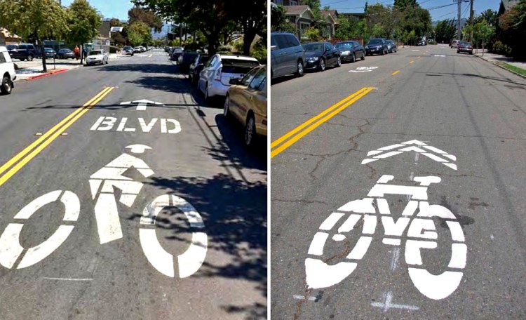
Mid-Block Bicycle Pavement Markings (three alternatives for discussion):
- Alternative 1: If low stress bike routes are going to be referred to as Bicycle Boulevards in maps and communication materials, install City of Berkeley style BIKE BLVD pavement markings (Figure 1).
- Alternative 2: If low stress bike routes are going to be referred to as Neighborhood Bike Routes in maps and communication materials, install sharrows per current City standards (Figure 2).
- Alternative 3: If low stress bike routes are going to be referred to as Neighborhood Bike Routes in maps and communication materials, develop new pavement marking that speaks to the branding goals identified in the plan.

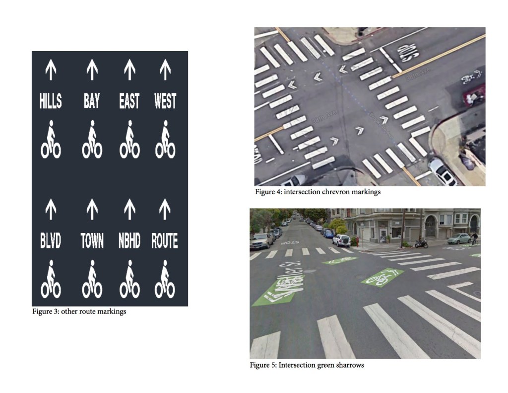
Intersection Bicycle Pavement Markings: Install shared lane intersection markings (chevrons) or green- backed sharrows through intersections per the following criteria:
- Unsignalized rectilinear Local/Local intersection, where both streets are 40′ wide or less: No intersection marking needed. May use chevrons if desired.
- Signalized and/or skewed intersections with four or fewer approaches, transitions to/from bike lanes (see markings at 38th Ave and Brookdale Ave), or where one or more streets is wider than 40′: Use chevrons (Figure 4).
- Offset intersections, intersections where bikeway turns, or complex multi-legged intersections (including across divided roadways): Use green-backed sharrows (Figure 5).
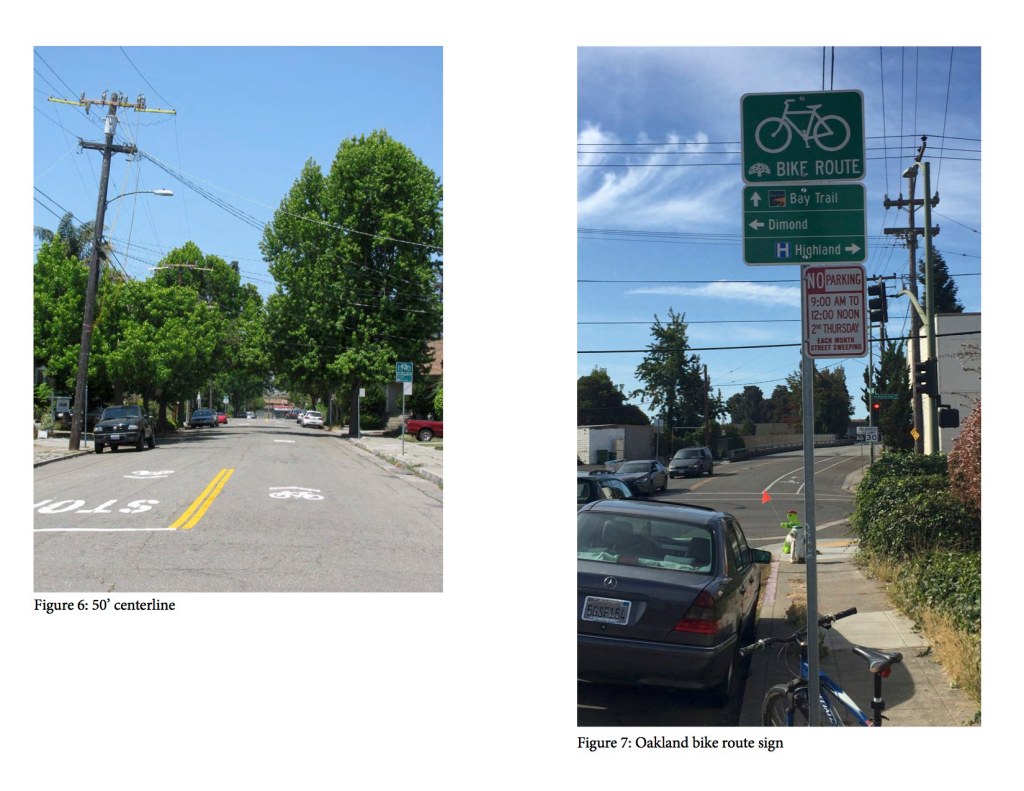
Other Pavement Markings: Speed hump markings, stop stencils (as needed), and centerlines (50 LF) approaching controlled intersections (Figure 6). Avoid the use of edge line stripes and continuous center lines.
Bicyclist Guide Signs: Install bicycle guide signs per current City standards (Figure 7). Additional placemaking signs may be added to complement bicycle guide signs when developed to address the following recommendation from the Bike Plan: “OakDOT will engage communities in a collaborative design process to develop placemaking signage for Neighborhood Bike Routes. The signs will complement bicycle wayfinding signage by depicting neighborhood identities.” (p.121)
Pavement Condition: Projects on existing or planned neighborhood bike routes should include paving if needed. If a project has limited budget for paving, the project should—at minimum—provide “make-safe” spot pavement repairs, or pave only the expected operational width of the bikeway (for a neighborhood bike route this would mean paving only the travel lanes and not the parking lanes).
Traffic Calming & Traffic Control
A neighborhood bike route may include traffic calming in response to measured traffic volumes and speeds, and special treatments at the crossings of arterial and collector streets.
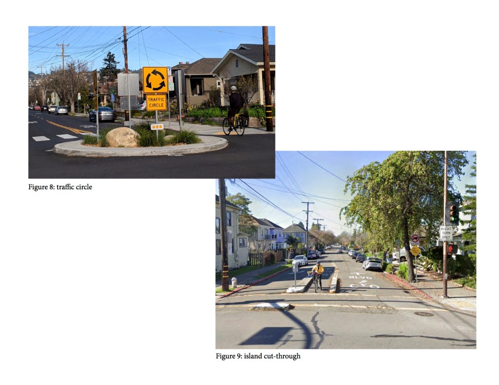
Volume and Speed Management: Discourage cut-through traffic and, if needed, reduce motor vehicle volumes and speeds through the implementation of traffic calming measures, such as speed humps, traffic circles (Figure 8), islands (Figure 9), and diverters (Figure 10). Traffic calming should be implemented (and only implemented) in response to traffic volumes and/or speeds that exceed OakDOT’s guidelines.

[NOTE: Recommendation for internal discussion: Base OakDOT guidelines on the speed and volumes in NACTO’s Contextual Guidance for Selecting All Ages and Abilities Bikeways which recommend that streets with traffic speeds and volumes below the following thresholds are appropriate for bicycle boulevards:
- Speeds less than or equal to 20 MPH, less than or equal to 2,000 average vehicles per day, and less than 50 vehicles per hour per direction at peak hour; or
- Speeds less than or equal to 25 MPH, less than or equal to 1,500 average vehicles per day, and less than 50 vehicles per hour per direction at peak hour.
Projects implementing bicycle boulevards on streets with traffic speeds and volumes above these thresholds should include traffic calming measures to bring speeds and volumes down.
Stop Control at Local Streets: To the extent feasible, minimize the number of stops on neighborhood bike routes.
- Intersections of neighborhood bike routes and local streets should be either (1) stop-controlled on the local approaches only (preferred); or (2) all-way stop-controlled.
- Before stops controls are changed, the MUTCD requires a traffic study. A standard study scope should be defined by OakDOT Safe Streets Engineering Section.
- Where stops remain on the neighborhood bike route, install the supplemental “all way” stop sign placard or “cross traffic does not stop” placard, as applicable (Figures 11 and 12).
- When stops are eliminated on a neighborhood bike route, conduct before/after monitoring of traffic volumes and speeds to determine if changes in stop control should be accompanied by traffic calming (if not already included).

Daylighting: Parking may be restricted up to 20 feet from the curb return on all intersection approaches. This may be challenging on residential streets in front of people’s homes and a standard process should be developed to evaluate and respond to concerns. (See Public Comment, below.)
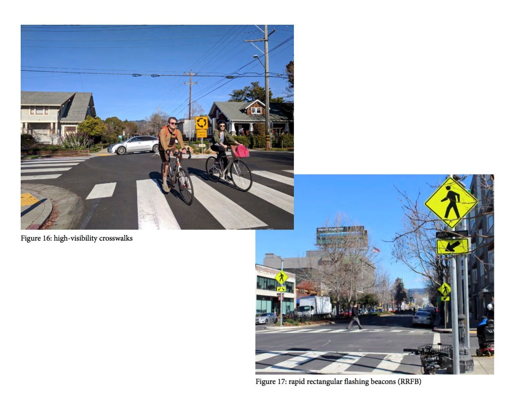
Uncontrolled Crossings of Collectors and Arterials: Install treatments that support bicyclists at uncontrolled crossings of collectors and arterials. Develop triggers for these treatments based on traffic speed, traffic volume, and crossing distance. Possible treatments include:
- Bicycle warning signs (Figure 14);
- “BIKE XING AHEAD” pavement legends;
- High-visibility crosswalks (Figure 16);
- Bikeway markings through the intersection;
- Stop control;
- Rectangular rapid flashing beacons (Figure 17);
- Pedestrian hybrid beacons with bicycle detection (Figure 18);
- Median islands (Figure 19);
- Curb extensions (Figure 20); and
- Traffic signals.

Offset Intersections at Collectors and Arterials: Bicycle boulevards should avoid shared-lane situations on the major street wherever possible. Offset intersection treatments may include:
- Bike lanes (Figure 21);
- Bicycle turn pockets (Figure 22);
- 2-stage turn queue boxes (Figure 23);
- Two-way cycle tracks (Figure 24); and
- Intersection signalization.

Traffic Restrictions: Access restrictions (Figures 9 and 10) should be considered on a case-by-case basis and be prioritized where the volume of cut-through traffic is incompatible with a street’s designation as a neighborhood bike route. Proposals for traffic restrictions may need an area-wide traffic study to determine where the traffic would be diverted to, communicate the diversion to affected residents, and potentially address impacts created by that diversion. Access restrictions should be designed to reduce or eliminate cut-through traffic while allowing local access (e.g., right-in/right-out only at collectors and arterials).
Public Notification and Comment
Like all bikeway projects, residents on and near proposed neighborhood bike routes should be notified of proposed projects during the early design phase when public comments could be addressed. Additional notification should be provided to residents immediately adjacent to the locations proposed for speed humps and traffic circles. This may be in the form of a letter mailed directly to those addresses. The public process should include an appeal process in order to manage conflict with a clear path to conclusion. The types of issues that provide a basis for appeal should be predefined (by this Guide) and identified in the public notification process. As part of this Guide, develop an internal OakDOT process whereby appeals are elevated to and decided by management.
Performance Measurement
OakDOT should work towards a monitoring system for neighborhood bike routes to ensure they are meeting the traffic thresholds noted above. If the route is not meeting those thresholds, additional traffic calming should be considered. This system should be designed in acknowledgement of the limited capacity for ongoing monitoring.
Future Steps & Outstanding Issues
Additional considerations to be fleshed out in the development of this Guide.
Emergency Response Classification Map: Work with OFD, OPD, and other stakeholders to develop a map of emergency vehicle stations and routes and seek additional review and vetting when proposing traffic calming on major emergency vehicle routes.
Advisory Bike Lanes: On neighborhood bike routes that are above a certain width threshold and meet the appropriate volume/speed/context requirements, consider experimenting with advisory bike lane striping/markings/signage.
