

At the January 12, 2023 BPAC Infrastructure Meeting, OakDOT staff Jason Patton to presented an update on Slow Streets before publicizing it in late January. An excerpt of the presentation is below, followed by the full presentation [PDF] and presentation notes and discussion notes.
Slow Streets Network
OakDOT proposes a Slow Streets Network based on the 75 miles of NBRs in the 2019 Bicycle Plan. (draft map)
- Some proposed NBRs (neighborhood bike routes) are on streets not suitable to be Slow Streets. These streets will be proposed for other bikeway types and they will remain part of the Bikeway Network. These streets will not be part of the Slow Streets Network.
- Additional streets should be added to the Slow Streets Network to create Slow Streets connections between more neighborhoods.
- All of the Slow Streets Network will be part of the Bikeway Network.
- Bicycle & Pedestrian Program staff will itemize and explain each proposed change for transparency and discussion.
Why would a proposed NBR not be included in the Slow Streets Network?
Some proposed NBRs function as through streets for motor vehicles. For these streets, can the through function be eliminated to create a Slow Street with limited local motor vehicle access? Recommendations will consider the following:
- Truck routes: Is the street a designated through route for trucks, for example, connecting industrial lands and highways?
- Bus routes: Is the street used by AC Transit as a through street?
- Emergency routes: Is the street used as a through street by the Fire Dept when traveling from fire stations to incidents?
- Street Network: Does the street provide a through connection in an area with limited street connectivity?
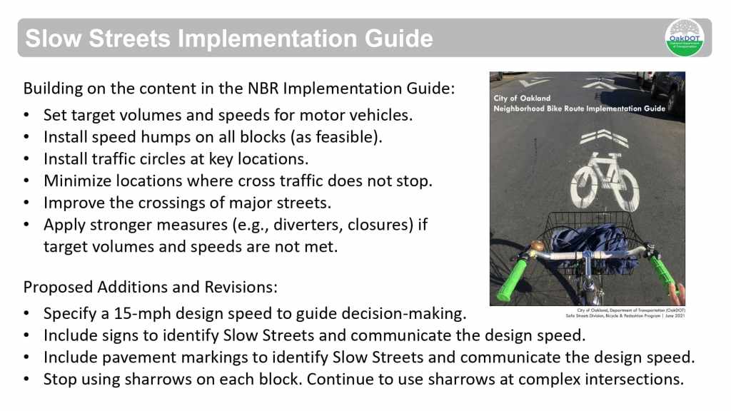
Slow Streets Implementation Guide
Building on the content in the NBR Implementation Guide:
- Set target volumes and speeds for motor vehicles.
- Install speed humps on all blocks (as feasible).
- Install traffic circles at key locations.
- Minimize locations where cross traffic does not stop.
- Improve the crossings of major streets.
- Apply stronger measures (e.g., diverters, closures) if target volumes and speeds are not met.
Proposed Additions and Revisions:
- Specify a 15-mph design speed to guide decision-making.
- Include signs to identify Slow Streets and communicate the design speed.
- Include pavement markings to identify Slow Streets and communicate the design speed.
- Stop using sharrows on each block. Continue to use sharrows at complex intersections.
Presentation


Presentation notes
- Background/history slide, including background on Oakland’s bike boulevard plans and implementation, then Slow Streets implementation since 2020
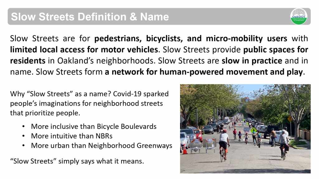
- Slow Streets definition/name slide, one part bike blvd network, one part greenway, one part public space – “Slow Streets” name proposed because it is intuitive & relevant to Oaklanders
- Network proposal slide – Will be some overlap with neighborhood bike routes (NBRs)/Bike blvds, but some NBRs might not be appropriate as Slow Streets and vice versa—Slow Streets should not be through streets for motor vehicles, whereas some NBRs might be (such as those that have segments which overlap with bus routes)
- Slide on street types – Local, collector, or arterial are official classifications—Some NBRs and Slow Streets were on collectors which are usually intended to be through streets, but if these don’t in fact need to serve through traffic these could be reclassified as local. Other streets may need to remain as collectors, and therefore a Slow Street shouldn’t be implemented there.
- Collector streets in residential areas are less common elsewhere, but Oakland has more of these than is typical
- Caltrans interactive web map of street classifications here.
- General info from Caltrans on street classifications here.
- Recent example: 8th Street, which had classification changed recently to “local” in order to implement neighborhood traffic calming.
- Some streets would also be added as a Slow Street or NBR in order to fill a gap and help complete the bike network
- Slow Street design principles slide – 15 mph design speed – Pavement markings & signage – Stop using sharrows each block
- How does the current NBR implementation guide apply?
- 50 miles of NBR on the current paving plan, so lots of opportunities for traffic calming (like speed humps or traffic circles) and intersection crossing updates
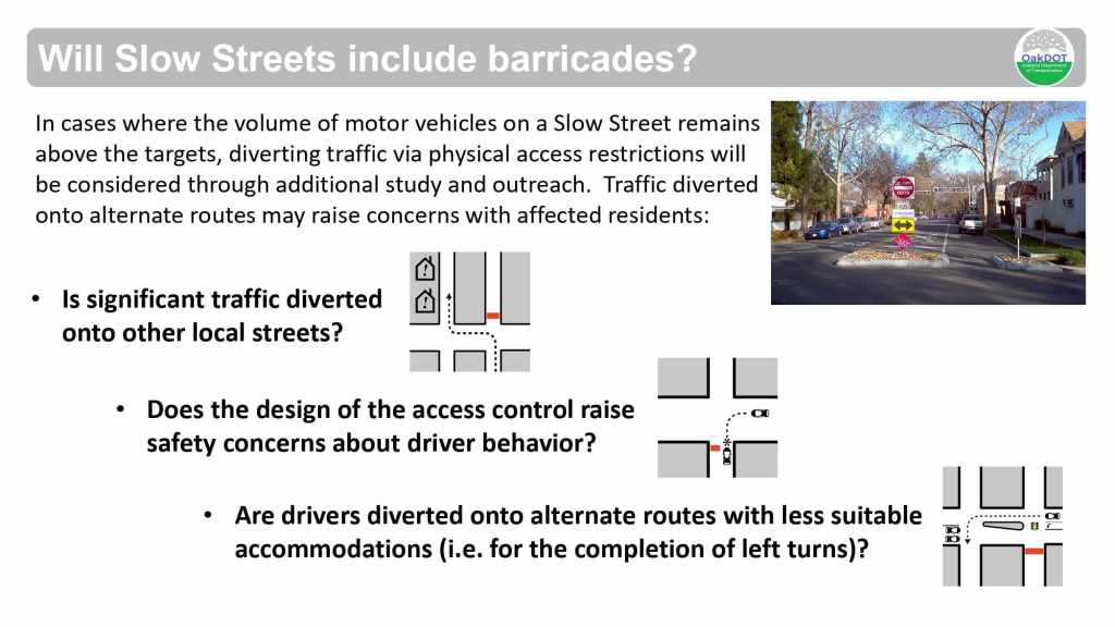
- Will Slow Streets include barricades?
- Answer is yes, but cautiously so.
- Guide has speed and volume thresholds. Many Oakland streets are already below these targets, some are above. Goal is to meet these goals with as little disruption as possible. If barricades are determined to be needed in order to meet the goals, then they will be considered. Also have to consider how much car traffic will be diverted to side streets, and possible conflicts of people proceeding around barricades
- Also looking at hardened center lines and sidewalk extensions (bulb-outs) as “gateway” treatments to slow turning speeds & help visually identify the Slow Street.
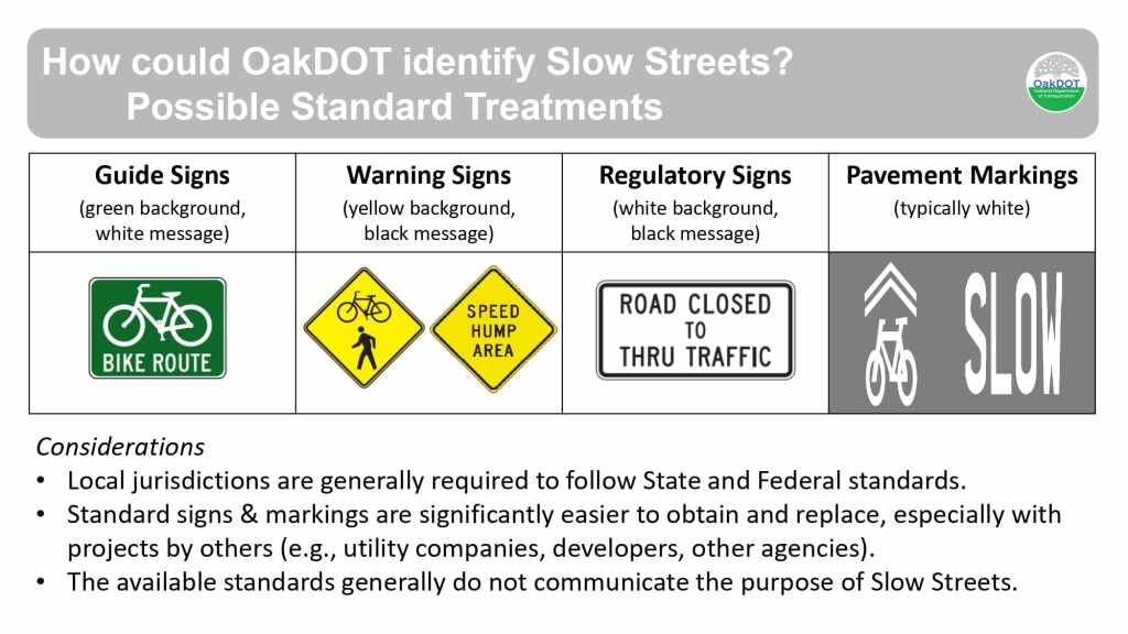
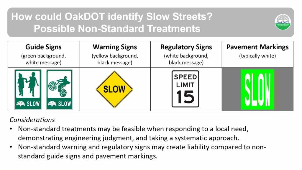
- Slow Street identification treatments
- Standard treatments: guide signs, warning signs, regulatory signs, and pavement markings
- Non-standard treatments: guide signs that have different artwork and/or shape, could vary between neighborhoods – thinking about two tone design. Pavement marking with “slow” in white on a green background (about the same size as a “stop” marking). Flexibility with non-standard treatments when methodical using engineering judgment, especially regarding guide signs and pavement markings—less so regarding warning and regulatory signs—state vehicle code doesn’t allow enforcement of 15 mph.
- Example slide showing preview of treatment on Plymouth St
- Adding to existing speed humps and traffic circles—Hardened center lines, new guide signs and pavement markings
- Deliver work through paving program, trying to keep up with large paving workload by keeping treatments lighter. Barricade proposals would be a separate process with more direct community engagement, ideally funded as Capital Improvement Program items
- Next steps slides on how public will be involved in implementation
Discussion notes
- Was 8th Street reclassified from collector to local?
- No, it was actually minor arterial to local. Process was not incredibly complicated, but getting a spot to get it approved on a city council agenda is difficult—In the future, staff hopes to bring a bunch of reclassification requests to council all at once.
- Regarding the “slow street” proposed markings, Commenter likes them because they take up the full lane and are bright colored so they’re easier to see
- Is there a different pavement marking to be used where Slow Streets overlap with NBRs?
- Intent is to replace NBRs with Slow Streets. In some instances where Slow Streets are infeasible but the corridor is still critical to the bikeway network then some other designation and treatment will be needed.
- Will public support be needed for vehicle speed and volume collection?
- Collecting the data is pretty straightforward, but city could use assistance with organizing the data. People can get in touch if they are interested in helping out.
- Some street classifications are historical artifacts left over from previous uses that are no longer relevant.
- Are speed humps going to still require a petition process?
- There are two channels now for speed humps—Still have a by-request petition process, but also now plan/project-specific process without petitions. This process for Slow Streets will now include a notification process to residents but not require petitions.
- Make sure markings aren’t just paint so they don’t wear away quickly—Might be good to have mid-block markings too.
- City tries not to use paint for any work. Ideally markings will be preformed thermoplastic installation to make it more durable.
- How will neighboring streets be notified/evaluated for diverters?
- Should be part of a larger traffic calming plan, with neighborhood-wide outreach process and plan
- Potentially implementation with before/after counts, and then follow up as needed
- Commenter likes the idea of approaching this on a whole neighborhood basis.
- Ideally a public announcement on Slow Streets plan will be made by end of January, then with a public presentation scheduled at the February BPAC meeting.
- Good idea in the public presentation to make it clear that Slow Streets are replacing NBRs.
- The upcoming announcement is a good opportunity to communicate with neighborhood services coordinators and neighborhood councils (some are meeting only every other month).
- Some opportunity for overlap with Paint the Town street murals program for prioritization of Slow Streets corridors.

Very exciting. I have high hopes for this roll out of SLOW STREETS and 15 MPH speed limits with street design changes.
Comments:
1. There are no bus routes on Champion Street between School & Harold. The map has this marked as an AC Transit bus route. Rt 20 & 21 utilize Harold and then Champion St but do not turn south of Harold.
2. 6XX bus routes are once per day. Seems reasonable to mark a 6XX routes differently, and hopefully co-exist with Slow Streets.
3. Seems like too many streets are marked ARTERIAL or COLLECTOR.
* Excelsior St between Park Blvd and Ardley is a block away from MacArthur and seems reasonable as an eligible street.
* Fruitvale Ave between MacArthur and Triffin Rd is blocks away from Lincoln Ave and relatively close to Park Blvd. Fruitvale in this area seems reasonable as an eligible street.
LikeLike
Excited to see these Slow Streets implemented with street designs and 15 MPH limits.
Some comments.
1. On the map, there is no bus route on Champion St between School St and Harold. AC busses 20 and 21 use Champion north of Harold.
2. 6XX school routes show as AC Transit routes but these are only 1/day so it seems appropriate to downgrade the severity and hopefully these can co-exist. Safer streets will benefit student pedestrians.
3. It seems like many streets are marked arterial and collector streets when next to many higher volume streets, limiting implementation of the Slow Streets.
* Excelsior St near Park Blvd is a block from MacArthur so this seems unnecessary to limit Slow Street implementation. Cars should use MacArthur for through Traffic.
* Fruitvale Ave between MacArthuer Blvd and Triffin is an excellent candidate for a slow street redo. Lincoln Ave is 2 blocks away, so it seems uneccessary to limit implementation of the Slow Streets.
LikeLike