Slow Streets–Essential Places Program Update

At the January 20, 2022 BPAC meeting, Megan Wier and Jason Patton, OakDOT staff in the Safe Streets Division, will present on upcoming changes to the Slow Streets–Essential Places Program in response to the ongoing and changing nature of the COVID-19 pandemic. Changes include removing the temporary Slow Streets and Essential Places materials, including temporary street closures, and shifting efforts to longer term strategies for pedestrian safety and neighborhood traffic calming. The presentation is below.
Read MoreJanuary 2022 BPAC Agenda
Thursday, January 20, 2021; 6:00-8:00 pm, online and by phone.
Agenda topics include:
- Recent Bicyclist and Pedestrian Related Crashes
- Nominations & Elections for BPAC Chair and Vice Chair
- Slow Streets–Essential Places Program Updates
Announcements:
- OakDOT is looking to hire Assistant Engineers and School Crossing Guards
- Ney Avenue Interim Traffic Calming Installation
- California Bicycle Summit in Oakland, April 6-9, 2022
- RAISE Grant Awarded for Reconnecting the Town Project
More details below.
Read MoreJanuary 2022 Infrastructure Committee Meeting
Oakland Waterfront Trail
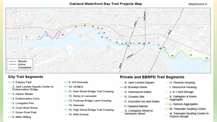
At the December 16, 2021 BPAC meeting, Kristin Hathaway, Watershed and Stormwater Division and Measure DD Program Manager, will present on the status of the Oakland Waterfront Trail.
As part of the $198,250,000 Measure DD Bond, a General Obligation bond approved by Oakland voters in 2002, $43,500,000 of the Estuary Waterfront Access category is designated for waterfront trail and parks acquisition and construction. Through this category of funding, Oakland is completing local segments of the regional San Francisco Bay Trail, a 500-mile walking and cycling path around the San Francisco Bay that passes through 47 cities and all nine Bay Area counties. The City has completed several segments and is in various stages of design on the remaining segments that still need to be constructed to close the Bay Trail gaps in Oakland.
The presentation is below.
Read MoreDecember 2021 BPAC Agenda
Thursday, December 16, 2021; 6:00-8:00 pm, online and by phone.
Agenda topics include:
- Recent Bicyclist and Pedestrian Related Crashes
- Thanking Commissioner RB
- Oakland Waterfront Trail
- Draft 2021 BPAC Chair’s Report
- Committee Report-Back
Announcements:
- Traffic Fatalities and Rapid Responses – CY 2021 to date
- OakDOT Major Projects Map Updates
- Montclair Demand-Responsive Parking Program
- Funding Exploration for Universal Basic Mobility Program
More details below.
Read MoreLeading Pedestrian Interval Downtown Project

At the December 2, 2021 Infrastructure Committee meeting, Dean Hsiao gave a presentation [PDF] on the Leading Pedestrian Interval (LPI) project in Downtown Oakland. The red dots on map are traffic signals that are going to updated with LPI, and green dots are ones that can not be updated due to older technology. Notes from the presentation and discussion are below.
- “Leading pedestrian interval” (LPI) — a walk light is provided a few seconds in advance of the green light for cars
- Studies show it can reduce car/pedestrian collisions up to 60%.
- 85 signals in the Downtown area being updated.
- 36 signals completed (northern half of Downtown)
- 49 remaining, to start in December (southern half of Downtown)
- Other locations in Downtown need to have signal controller tech updates to allow for retiming, or to add pedestrian walk signal heads.
Sideshow Prevention Pilot Project
At the December 2, 2021 Infrastructure Committee meeting, Joe Wang and Brian Sukkar gave a presentation [PDF] on the Sideshow Prevention Pilot Project.
The program started in late spring-early summer. Sideshow activities increased by a lot during pandemic.
Oakland PD reached out to OakDOT for help, and OakDOT reached out to other jurisdictions to learn from their experiences.
Notes from the presentation and discussion are below.
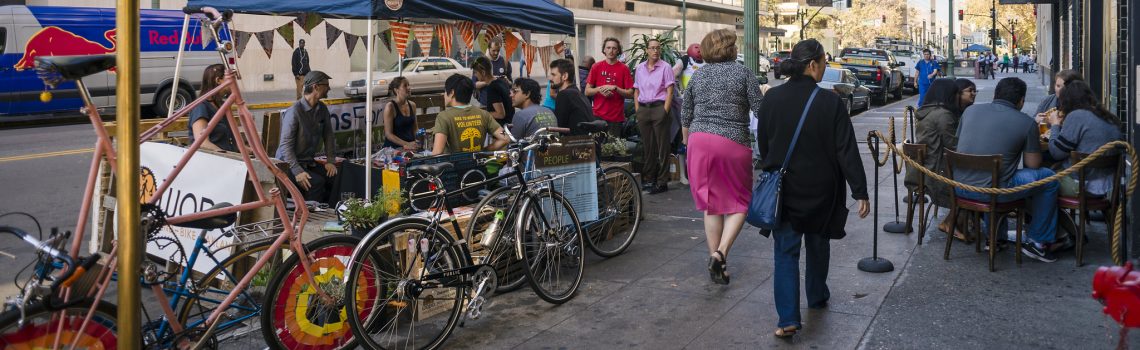
Read MoreOakland CityRacks Bicycle Parking Program
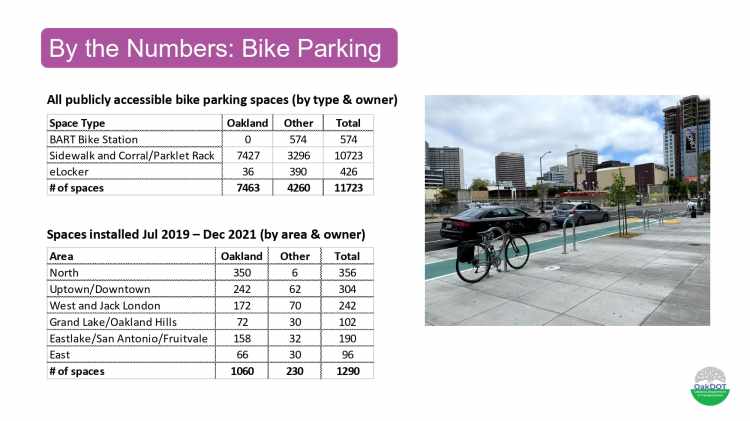
At the December 2, 2021 Infrastructure Committee meeting, Pierre Gerard gave a presentation on the CityRacks Bicycle Parking Program. Notes from the presentation and discussion are below.
- The City bike rack map is currently up to date through July 2021.
- 1290 racks installed Jul 2019-Dec 2021 (1060 by city, 230 other)
- 96 new racks were installed in East Oakland—specific focus is to increase the number of racks in commercial zones in this part of the city.
- There is a new online rack request form, which has better integration of Spanish and Chinese text.
